Sunday, February 28, 2010

Traversing the Tsunami - Golden Gate Bridge Running

Run date: February 27, 2010
Run time: Afternoon

One of my favorite things about running in a tourist zone is passing bicyclists going uphill. This is not a knock on such people, but many of the tourists who rent bicycles are interested in a leisurely ride. Ergo, they do not feel the need to power up hills. It is fun to power up hill by foot and pass cyclists who are weighed down by their cameras and their sightseeing.


Editors note: Plenty of other cycling tourists did pass Josh going uphill as well, but he apparently did not feel the need to mention that

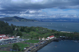
I spent a long early afternoon (two hours) waiting from a high point in the shadow of the Golden Gate Bridge for the forecast tsunami to arrive. Not knowing what a normal tide looked like, I wasn't really able to distinguish it. Some of the waves were pretty rough and spilling over the barrier onto the sidewalks, but nothing overly threatening.


tsunami?


Having stood so long staring at the bridge and the beauty across it--not to mention acting as everyone's personal photographer--I decided to run across it and explore the other side a little. I took my trusty GPS with me for your constant and unceasing enjoyment.


View 2-27-2010 in a larger map

I hope that by now you have realized that these maps are interactive. You can zoom in and explore if you'd like. I posted the original zoomed out so far so that you can take in the whole bay neighborhood as I did from afar the whole day.

Unfortunately, there doesn't seem to be a foot path from the north side of the bridge to Sausalito. What a crime. The road there is narrow and windy, so I opted not to run, at least not on this day.

At one point on the run across the bridge, there was a clearing, so I took off as fast as I could. There is something exhilarating about sprinting across the Golden Gate Bridge, probably enhanced by the fact that it was my first time setting foot there.

A small piece of me would like to run across the entire length as fast as I can. It could be a Golden Gate Bridge PR time trial of sorts.... We will see how that idea develops. There are so many other beautiful places I would like to run in this city first.

Here are so photos I took during the run, without geotags because I am bitter that HTC Footprints is not importing properly.


Always an engineer.

Oops how did that get in there?

Trail head right next to the north side of the bridge. I will check this out later.
Created by My Tracks on Android.

Total Distance: 9.08 km (5.6 mi)
Total Time: 1:05:18
Moving Time: 48:41
Average Pace: 7.19 min/km (11.6 min/mi)
Average Moving Pace: 5.36 min/km (8.6 min/mi)
Min Pace: 3.03 min/km (4.9 min/mi)
Min Elevation: 3 m (9 ft)
Max Elevation: 73 m (238 ft)
Elevation Gain: 272 m (894 ft)
Max Grade: 4 %
Min Grade: -18 %
Recorded: Sat Feb 27 14:28:05 PDT 2010

Thursday, February 25, 2010

Six Miles in Golden Gate Park, San Francisco, CA

"That's John F. Kennedy Drive."
"Who the hell is John F. Kennedy?"

Run Date: February 25, 2010
Run Time: Afternoon
Run Weather: Sunny, 55 degrees.
Distance: 6 Miles
Pace: Easy

I took my first run in San Francisco, CA today, and it was a blast. I am not sure if it was the weather or the fact that I hadn't run for a week, but I felt terrific. At the beginning, I was a little nervous about running even an easy 6 miles after it had been so long, but I was fine. The challenging hills of San Francisco were still no match for me.

It turns out that Golden Gate Park is amazing. It also turns out that the coast of San Francisco is amazing. Why didn't anyone ever inform me of this? It is as though my life has been one great big lie until this point in time, now having seen the beautiful sight I saw upon emerging from the wooded park to the ocean and towering hills.

These photos, taken on my phone really don't do justice, it is sad to say. However, imagine you are me. Imagine you think the SF coast is a big flat beach just like so many other beaches you've been to (I'm talking to you, Florida!). You are in the woods, but you can sort of see the water poking through. Eventually, the trees fall all the way back so that you can see the entire coast, and you are slapped in the chest by huge hills lining the coast. Straight in front of you is that sandy beach you knew, but northward is a national coastline. I almost cried. It was weird.

Please excuse the technical difficulties. The map markers aren't linking to the photos, but they are below.


View 2-25-2010 in a larger map


I grew up on the prarie, but I had to come to California to see bison. Have I seen bison before this? Maybe from the highway....


Sunday, February 14, 2010

RACE DAY - Heart Throb 5K

Race Date: February 14, 2010
Target Time: 21:59
Official Time: 22:30 (?)
Race Distance: > 5K :)

Once again I receive race results. And once again I am stuck on the 22:00 plateau I've been on since last May. Though it is disheartening to be so far off my personal record of 22:02 after more than four months of intense training, it's okay. I probably could have pushed harder. The course was actually 3.23 miles rather than 3.1 miles. The one mile marker was at 0.9 miles....The two mile marker was at 2.1 miles....(Thank you GPS for all this information) Though I may have just barely beat my PR on the first 3.1 miles of the course (unofficially), it is certainly clear that when you get to this point, you have to accept small incremental improvements. After all, I only started running less than two years ago. How long does it take to develop the necessary aerobic capacity for a 20:00 minute 5K after a sedentary lifestyle for my first 26 years?

I enjoy it all. I enjoy the training, and I enjoy the fitness.


View 2-14-2010 in a larger map

Total Distance: 5.28 km (3.3 mi)
Total Time: 23:21
Moving Time: 22:36
Average Pace: 4.42 min/km (7.1 min/mi)
Average Moving Pace: 4.28 min/km (6.9 min/mi) <--sub 7:00; sub 22:00! (sigh)
Min Pace: 2.89 min/km (4.6 min/mi)
Min Elevation: 209 m (684 ft)
Max Elevation: 233 m (764 ft)
Elevation Gain: 85 m (280 ft)
Max Grade: 7 %
Min Grade: 1 %
Recorded: Sun Feb 14 12:03:09 EDT 2010
Activity type: race running


Thursday, February 11, 2010

A weekend of running in Cascade, MI

Run Dates: February 6-7, 2010
Run Times: Daytime.

In this, the third post for today (playing catch up) I give you the two runs I took while in Cascade, MI this past weekend. Surely, these would be more interesting to third parties if I had taken pictures. Consider my lesson learned. In the meantime, just sit in awe at how many miles I ran. I am so awesome. ME ME ME ME ME.

I did notice that a mere 2 out of 15 people smiled or acknowledged my existence as I passed them on the trail. It was kind of unusual. One of the guys who did talk to me was pretty nice though. He was walking his dog and pointed out to me that it was cold and I was brave. I know I am, sir.

Saturday, February 6--6 Miles:


View 2-6-2010 in a larger map

Created by My Tracks on Android.

Total Distance: 9.65 km (6.0 mi)
Total Time: 45:12
Moving Time: 43:49
Average Pace: 4.68 min/km (7.5 min/mi)
Average Moving Pace: 4.54 min/km (7.3 min/mi)
Min Pace: 3.33 min/km (5.4 min/mi)
Min Elevation: 139 m (456 ft)
Max Elevation: 204 m (669 ft)
Elevation Gain: 209 m (687 ft)
Max Grade: 9 %
Min Grade: -24 %
Recorded: Sat Feb 06 16:34:13 EDT 2010
Activity type: street running


Sunday, February 7--12 Miles:


View 2-7-2010 in a larger map

Created by My Tracks on Android.

Total Distance: 19.25 km (12.0 mi)
Total Time: 1:45:51
Moving Time: 1:40:04
Average Pace: 5.50 min/km (8.8 min/mi)
Average Moving Pace: 5.20 min/km (8.4 min/mi)
Min Pace: 3.51 min/km (5.6 min/mi)
Min Elevation: 155 m (509 ft)
Max Elevation: 213 m (699 ft)
Elevation Gain: 331 m (1085 ft)
Max Grade: 13 %
Min Grade: 2 %
Recorded: Sun Feb 07 14:21:43 EDT 2010


Actually, the 12 mile run had some killer hills. Of course, Hilary claimed to have not known this when she devised the route, but I am skeptical. Just kidding. It is interesting that there were so many steep hills, I apparently climbed over 1,000 feet cumulatively over the run.

Don't forget to turn off your GPS when you're done running.

Run date: February 4, 2010
Run time: early evening.

On the fourth of February, I did some pretty hard 800m repeats (six of them). I decided to go ahead and do the whole GPS thing. I had this elaborate idea of numerical analysis of repeats vs jogs inbetween and reducing the data so that you could tell what my pace was.

Well that didn't work out.

But this is funny. I forgot to turn off my GPS when I got in the car to drive back to campus. You can see where I parked, see me drive out of the parking lot, and see me arrive at a new parking spot on campus and walk back into my office. So cool, I know.


View 2-4-2010 in a larger map


View 2-4-2010 in a larger map

Revoke my license.


View 2-4-2010 in a larger map


View 2-4-2010 in a larger map

Tips for running on campus at night

Run date: February 3, 2010
Run time: Like 11 PM.

So last week (Feb 3), I was working late in my office, and I decided it would be a good idea to hold off on my run until it was late and dark. Straightforward as this may seem, I must present you with tips for running on MSU's campus at night.

But first, the goods:


View 2-3-2010 in a larger map

Tips for running on campus at night.

1.) Other people--they are more afraid of you than you are of them.

While running at night on the dark lonely pathways, you may find yourself a little timid as you see another figure approaching in the night. However, don't break out of that great form you have developed from your hours and hours of relentless training. Always remember that these people, most likely, are more afraid of you than you are of them.

I realized this while passing a young chap carrying a giant backpack. He froze as he saw me approach, and as I passed, he took off running, and his backpack followed behind him after a cartoonish delay.

After all, let's compare the auras of the figures passing in the night. You run up towards a young studious lad on his way home from the library. Remember--as a runner who braves the cold weather and fierce wind, you have prepared adequately by wearing gear that covers all of your exposed skin. Because you are so stylish, these happen to be dark colors. You are a menacing figure. You look like this:

Meanwhile, our poor student who embarks out bravely into the cold has this not-so-intimidating appearance:


Be polite.

2.) Eat something extra

You may be wondering why this course was shorter than usual. It's because after two miles, I crashed. It had been a few hours since I had eaten dinner, and my body just wanted to go to sleep. I had to cut things a little short for a total of three miles. This phenomenon could be prevented by eating a common banana--also known as a "bannann" or "hello yellow"--before you head out.

Of course, it may so happen that if you run late regularly, your body will be used to the biochemical rhythm. Something like that. I have no idea what I'm talking about.

Created by My Tracks on Android.

Total Distance: 5.86 km (3.6 mi)
Total Time: 30:44
Moving Time: 30:12
Average Pace: 5.22 min/km (8.4 min/mi)
Average Moving Pace: 5.15 min/km (8.3 min/mi)
Min Pace: 3.68 min/km (5.9 min/mi)
Min Elevation: 214 m (703 ft)
Max Elevation: 277 m (909 ft)
Elevation Gain: 164 m (538 ft)
Max Grade: 0 %
Min Grade: 0 %
Recorded: Wed Feb 03 22:31:13 EDT 2010
Activity type: street running

Tuesday, February 2, 2010

To Yak or not to Yak? And more physics in running.

Run date: February 2, 2010
Run time: Dusk.

To Yak or not to Yak?

That is, I suppose, the question that many runners ask themselves at the end of a hard fought race. But it is also the question I asked myself this evening before my run--not in reference to losing my oatmeal but in reference to whether to put YakTrax on my shoes for better traction in the light snow.

If the snow is more than about a half inch, YakTrax become beneficial as they keep your feet from sliding around. If you run with them on dry ground or a light dusting, they take away from your power and can become uncomfortable. Because I was running on campus, I figured most of the sidewalks would be clear from the heavy foot and bike traffic, and for the most part I was right.


View 2-2-2010 in a larger map

Some of the features of my surroundings I often notice while trekking through this weather are interesting snow formations. I picture the wind as a vector field flowing across the ground and around obstacles to distribute the loose powdery snow as a visualization of its movement. This is similar to the fun young kids (and old me) have dusting iron filings onto a bar magnet to visualize its magnetic field.

Today I noticed something curious, not for the first time, but for the first time I was able to stop and take a picture--along with a GPS tag of course! (Denoted on the map by blue tags) Most of the sidewalk on which I was running had a very light dusting of snow. This particular stretch has a wind tunnel that I feel every time I run down it, particularly on cold days. Most of the time, the snow has blown off the flat sidewalk. While passing sections of sidewalk next to trees, however, the snow remains at full depth. I don't quite understand how this happens, but the trees must somehow break the wind or redirect it away from the sidewalk below.

In the foreground of this image, you see the thin dusting that was characteristic of most of the sidewalk. Next to the trees, the wind patterns have changed enough that the snow doesn't blow off so easily.

Another thing I often notice in these weather conditions is the fact that underground tunnels--what I assume to be utility tunnels--become quite visible because the snow melts above them. This leaves a pathway of bare ground following the tunnel below. I didn't run past a great example tonight, but here is the best I could do, especially while losing daylight rapidly:


Usually, a manhole is a good hint, as it is in this case, but it's not necessary. Extending towards the background, you can see a bare stretch of land following the tunnel. There is a very nice example of this in the central part of campus--a large tunnel, but I wasn't running past it today. I have come up with a couple possible reasons for this.

1) The fact that the tunnel is filled with air doesn't allow heat to be extracted as quickly by the surrounding ground (convection vs conduction). It takes longer to cool the tunnel and the dirt above it to below freezing.
2) These are tunnels carrying small water pipes that are intentionally heated to prevent freezing. It takes longer to cool the dirt above the tunnel. They may be intentionally heated for a different reason, but this makes the most sense to me.

I think (1) would be most interesting. I don't know the actual cause, but if anyone has some insight, as always I'd love to hear it.

Created by My Tracks on Android.

Total Distance: 9.94 km (6.2 mi)
Total Time: 54:45
Moving Time: 51:16
Average Pace: 5.49 min/km (8.8 min/mi)
Average Moving Pace: 5.16 min/km (8.3 min/mi)
Min Pace: 3.03 min/km (4.9 min/mi)
Min Elevation: 211 m (692 ft)
Max Elevation: 252 m (826 ft)
Elevation Gain: 228 m (747 ft)
Max Grade: 5 %
Min Grade: -5 %
Recorded: Tue Feb 02 17:44:07 EDT 2010
Activity type: street running


Monday, February 1, 2010

Lansing 12 Miles. Make that 8 Miles.

Run date: January 31, 2010
Run time: Dusk.

It happens to the best of us. We all experience the occasional run that does not go exactly as planned. Nearly two years ago, as I began the running phase of my life, the failed training run hit my pride hard and in the face. Now I accept it as a fact of life....

....Who am I kidding? It still knocks me down a little when I don't complete a training run at the proper speed or distance. However, when the reason for the failed run is the total and utter death cold wind of the upper United States, at least I have something other than my body to blame.

Late this afternoon, before the sun set, I set off on my weekly long run. This week it was 12 miles. The weather was beautiful--a sunny 30 degrees. I dawned the appropriate gear to stay warm under such conditions: long sleeve Smart Wool, long sleeve tech shirt, gloves, pants, merino wool balaclava.

Unfortunately, I failed to realize the possibility that the temperature might actually drop after the sun went down. Stupid enough. But okay that will be a little cold.

When you run, you sweat. It doesn't matter how cold it is outside--your body produces heat to the point that it thinks that sweating will help you out. The idea is to wear running gear in the cold that will wick this sweat away from your skin or block the wind from finding that moisture.

Ergo, when you set out to run in beautiful and sunny 30 degree weather, dressed appropriately, you sweat. Then the sun goes down. Then the wind starts gusting. Then you realize that the brilliant piece of Smart Wool that is the balaclava dividing your wet head from the wind gust is a lot thinner than you think.

As I felt my head rapidly lose heat, I, like any idiotic prideful runner, continued to run for a few more miles, doing the best I could to dry off my face and hair with my gloves. Then my gloves became quite wet as well.

As the cold Michigan wind clamped its massive jaw down on the sides of my head and the tips of my fingers, it soon found a way to cut through the two shirts I had protecting my torso. Had I begun my run in these weather conditions, I would have dressed more appropriately and been perfectly fine. Instead of the long sleeve tech, my outer layer would have been a thick #3 capilene, perhaps even an additional windbreaker. I would have worn a thicker hat in addition to the balaclava. I wouldn't have needed to dry my face and head off with my gloves that became unbearably wet.

One more mile.

Excruciating pain. This is not the pain of the sore hamstring or the nagging ankle. This is the pain of standing out at the bus stop in the fourth grade with wet hair. This is the pain of walking down the driveway to get the newspaper in the morning without putting on a jacket or pants. However, instead of having the bus pull up beside me or my front door and breakfast table nearby to save me, I still had four miles to go.

Luckily, I am a huge nerd, and I happen to carry around my new phone so that I can log my runs on GPS (who knew??). I stopped in the vestibule of a university-owned inn on the secluded southwest corner of campus. Because the balaclava made me look like a bank robber, they didn't really want to let me in all the way. I used my phone to call my friend Megan. And she came to pick me up. I was defeated.

Here is a map of the incomplete journey. I made it 8 out of the 12 miles. Not so bad for such a life threatening ordeal.


View 1/31/2010 - First 8 Miles in a larger map

Total Distance: 13.27 km (8.2 mi)
Total Time: 1:11:32
Moving Time: 1:09:00
Average Pace: 5.35 min/km (8.6 min/mi)
Average Moving Pace: 5.20 min/km (8.4 min/mi)
Min Pace: 3.17 min/km (5.1 min/mi)
Min Elevation: 205 m (671 ft)
Max Elevation: 236 m (775 ft)
Elevation Gain: 221 m (726 ft)
Max Grade: 9 %
Min Grade: -7 %
Recorded: Sun Jan 31 16:27:26 EDT 2010


After contacting Megan, I decided to keep running until she passed by in her car to pick me up. At this point, my body had cooled down, and the cold was even more excruciating. GPS still running, here is a map of the jaunt outwards. The turnaround point indicates where I decided it was way too cold to do anymore, and I turned right back around and into the vestibule.


View 1/31/2010 - Whoops Too Cold in a larger map

Total Distance: 0.67 km (0.4 mi)
Total Time: 3:50
Moving Time: 3:23
Average Pace: 5.35 min/km (8.6 min/mi)
Average Moving Pace: 5.06 min/km (8.2 min/mi)
Min Pace: 3.89 min/km (6.3 min/mi)
Min Elevation: 230 m (753 ft)
Max Elevation: 242 m (793 ft)
Elevation Gain: 6 m (19 ft)
Max Grade: 0 %
Min Grade: 0 %
Recorded: Sun Jan 31 17:42:12 EDT 2010


To pay Megan back, I told her I would buy her dinner. Too bad we went to YaYa's. The chicken was surprisingly good. Everything else was as disgusting as you have always imagined. At least it was warm...kind of.

Five Miles in Spring Lake, MI

Run Date: January 30, 2010
Run Time: Early Afternoon

As always, these maps are produced using actual GPS data acquired during my run by My Tracks.
The map is an interactive Google map.

Spring Lake and the surrounding area has miles of running and biking trails that could serve as inspiration to any municipality interested in improving health and developing complete streets.

Training schedule: 5 Miles Easy (via Runners World SmartCoach).

This course was out 2.5 miles and back for a total of 5 miles. I was supposed to run it at 8:50 pace, but I have been doing these easy runs at 8:00-8:20 lately, perhaps because it has been so nice and sunny.


View Spring Lake 5 in a larger map

Created by My Tracks on Android.

Total Distance: 8.06 km (5.0 mi)
Total Time: 40:15
Moving Time: 39:49
Average Speed: 12.06 km/h (7.5 mi/h)
Average Moving Speed: 12.15 km/h (7.6 mi/h)
Max Speed: 16.30 km/h (10.1 mi/h)
Min Elevation: 133 m (436 ft)
Max Elevation: 172 m (564 ft)
Elevation Gain: 132 m (433 ft)
Max Grade: 10 %
Min Grade: 9 %
Recorded: Sat Jan 30 14:38:03 EDT 2010
Activity type: street running

GeoRunning

In geotagging, hikers or simple explorers take photos of points or events of interest. While doing so, they are also carrying a GPS, often within the same device. They are then able to post the photos on a map for their own reference or for novel forms of publication.

I recently purchased an HTC Hero phone, an Android device. It comes with well-revered geotagging software, Footprints, but I am more interested in using its GPS capability to log my running routes--for my own reference, your entertainment, or your bewilderment at why anyone would care.

I will call this georunning, though I suppose the activity already exists under the same or similar name. In fact, the term geotagging itself may encompass activities such as georunning. I am using a program by the people at Google called My Tracks. Initially, this will allow me to post maps and training data for my runs. With more work, I would like to include photos along common running routes, geotagged of course. I would have to stop running to photograph and tag every running course, and who wants to stop running on a new and beautiful course?

We will see how this develops. Let me know if there is anything I could do to make this more useful to anyone other than myself.